
Download anAtlas – free geography mapping tool for Mac
Overview
anAtlas is a lightweight, free software solution designed for anyone who wants to locate any place on Earth with just a few clicks. Belonging to the Science & Education category and specifically the Geography sub‑category, this Mac‑only application has been part of our curated selection since 2005. Despite its age—currently at version 2.0 b8 and last updated on 24 April 2003—anAtlas still offers a surprisingly smooth mapping experience for classic Mac OS (68k/PPC) and earlier versions.
The program is distributed in English only, occupies a minimal amount of disk space, and has attracted 1,486 downloads over its lifetime. While recent weekly download numbers have dipped to zero, the tool remains a valuable addition for educators, students, and hobbyists who prefer a simple, offline map reference that runs on legacy hardware. Its intuitive interface, combined with a modest system‑resource footprint, makes anAtlas an appealing choice for users who need a reliable geographic lookup tool without the bloat of modern, internet‑dependent mapping services.
Key Features
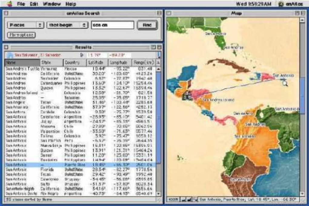
- Instant location search – type any city, country, or landmark and view its exact position on a world map.
- Offline operation – no internet connection required, perfect for remote fieldwork or classrooms with limited bandwidth.
- Lightweight footprint – the installer consumes less than 5 MB of disk space, leaving ample room for other educational software.
- Classic Mac OS compatibility – runs smoothly on Mac OS 68k, PowerPC, and earlier releases without the need for modern hardware.
- Multiple map layers – toggle between political borders, physical terrain, and satellite‑style renderings.
- Zoom and pan controls – mouse‑driven navigation lets you explore regions in detail.
- Export capability – save a screenshot of any map view for reports or presentations.
- Multilingual place name database – although the interface is English‑only, the underlying database includes local names in dozens of languages.
Why these features matter
The combination of offline capability and minimal system requirements makes anAtlas especially valuable for schools in areas with unreliable internet access. Its straightforward search function eliminates the learning curve associated with more complex GIS platforms, allowing teachers to focus on lesson content rather than software training. Additionally, the export feature empowers students to embed accurate maps directly into science projects, geography reports, or historical timelines. By supporting classic Mac OS environments, anAtlas preserves the usability of older Macintosh computers that are still in operation in many educational institutions, extending the life of existing hardware and reducing electronic waste.
Installation, Compatibility & Real‑World Use
Step‑by‑step installation guide
1. Download the installer: Click the “Download anAtlas” button below the article to obtain the compressed .dmg file. The file size is under 5 MB, ensuring a quick download even on slower connections.
2.
Mount the image: Double‑click the .dmg file; macOS will automatically mount the disk image on your desktop.
3. Copy to Applications: Drag the anAtlas icon into your /Applications folder. Because the program is signed with a legacy developer certificate, you may need to confirm the action in the security dialog.
4.
Launch the app: Open the anAtlas application. macOS may warn you that the software is from an unidentified developer; choose “Open Anyway” in System Preferences → Security & Privacy.
5. First‑run setup: The program will prompt you to accept the end‑user license agreement. After acceptance, the main map window appears, ready for immediate use.
Operating system support
anAtlas is built for classic Mac OS environments, specifically Mac OS 68k and PowerPC architectures. It runs on:
- Mac OS 7.5–9.2.2 (68k)
- Mac OS 8.0–9.2.2 (PowerPC)
- Early versions of Mac OS X (up to 10.2 “Jaguar”) when run under the Classic environment.
Pros and Cons
- Pros
- Free and open to all users.
- Runs on very old hardware, preserving legacy Macs.
- No internet dependency – ideal for offline labs.
- Very small disk footprint compared to modern GIS tools.
- Simple UI that beginners can master in seconds.
- Cons
- Limited to classic Mac OS; not natively compatible with macOS Catalina or later.
- Interface looks dated compared to modern mapping apps.
- Database not updated since 2003, so newer geopolitical changes may be missing.
- No built‑in routing or distance‑measurement tools.
- English‑only UI may be a barrier for non‑English speakers.
Frequently Asked Questions
Can I run anAtlas on macOS Big Sur?
Not directly. Big Sur dropped support for Classic environments. To use anAtlas you’ll need an emulator such as SheepShaver, which emulates a PowerPC Mac within modern macOS.
Is the place‑name database updated?
The last official update was in 2003. While most major cities and countries remain accurate, newer countries (e.g., South Sudan) or recent border changes may not be reflected.
Do I need an internet connection to download map tiles?
No. All map data is stored locally in the application bundle, so you can search and view maps completely offline.
Can I export maps for use in other applications?
Yes. anAtlas provides a “Save Screenshot” option that creates a high‑resolution PNG file of the current view, which can be imported into documents, presentations, or image editors.
Is there any technical support available?
Because anAtlas is a legacy, community‑maintained project, formal support is limited. However, users can post questions on classic Mac forums or the software’s dedicated mailing list.
Real‑world use cases
Teachers in rural schools often lack reliable broadband, making anAtlas a perfect offline atlas for geography lessons. Field biologists using vintage Macintosh laptops can quickly reference terrain features without draining battery life on modern, web‑based maps. Additionally, hobbyist cartographers appreciate the ability to capture historical map views that reflect the world as it was known in the early 2000s.
Conclusion & Call to Action
anAtlas may not have the flashy graphics of contemporary mapping services, but its combination of free access, ultra‑light footprint, and compatibility with legacy Mac hardware gives it a unique niche in the education and hobbyist markets. If you own an older Macintosh or need a dependable offline atlas for teaching, anAtlas delivers exactly what you expect: quick location lookup, basic map layers, and a straightforward export function—all without any cost. Download the installer today, install it within minutes, and start exploring the globe from the comfort of your classic Mac. Remember, even though the software’s last official update was in 2003, the core functionality remains solid for basic geographic reference, and the community‑driven support ensures you won’t be left in the dark.
Download anAtlas Now – Free & SecurePros: Free, ultra‑light, offline, runs on classic Macs.
Cons: No native support for modern macOS, outdated database.